And here we are, some 12 years later, about to begin the
journey to the real life Middle Earth. The Goon Squad was completely back
together for the first time in about a month and joining us were Shane, the
Californian surfer who went with us to Oktoberfest, and Lou, another hilarious
Bentley dude. We had planned our New Zealand trip in our second week here that
coincided with our “study week” at Bond, so it gave us the most time to explore
the beautiful countryside. In the few days leading up to our odyssey, we
cranked out as much of our final assignments as we could, then rewatched the
Lord of the Rings trilogy. Despite it being the bagillionth time I had seen the
movies, we had to do it, it’s like an unwritten rule of New Zealand. They just
never get old.
On Saturday morning, we boarded our flight leading us
from the sunny Gold Coast to Queenstown, New Zealand; the adventure capital of
the world. I had made sure to get a window seat for landing, per the advice of
a few Aussies we had talked to. A thick cloud layer covered the ground so upon the
beginning of our descent, I still not had caught a glimpse of the country. As
we began to dip closer to the seemingly impenetrable layer of clouds, the pilot
came on the loudspeaker stating that the airport in Queenstown was in a steep
valley that required us to fly in-between some large mountains before landing,
and not to be worried by the proximity of the peaks in a few minutes. I looked
over at Matt sitting next to me and we both did one of those little toddler
bounces of excitement.
We dropped lower and lower until the plane was finally
engulfed in the swirling whiteness of the clouds. Only a few seconds went by
before huge silhouettes began appearing out the windows. The further we
dropped, the clearer the dark shadows became until all of a sudden, we were
thrust through the bottom of the cloud layer, and there it was: New Zealand.
Our collective jaws dropped on the spot. Much like the pilot warned, we were
indeed flying in a huge valley being flanked by massive snowcapped peaks. It
was incredible. A lake could be seen far to the right with even larger
mountains rising straight from the waters and into the clouds. Only grasses and
small shrubs dotted the sides of the mountains, giving them the appearance of
being taller and more foreboding than they already were. It was indeed a
different world. In the words of Elijah Wood (Frodo Baggins), “New Zealand is
Middle Earth. It has every geological formation and geographical landscape you
can imagine, and some you can’t.”
It seemed appropriate then, as we flew across the lands
that inspired one of the best film series of all time that we listened to the
soundtrack that is as iconic as the landscape. So Matt and I did. The hype
level rose considerably. We flew lower into the valley, passing the sharp rocky
peaks of the Southern Alps and over the rolling foothills of Queenstown. The
airport was situated on likely the only flat piece of land in the country and
was so perfectly nestled between the peaks that it was obvious to see why they
call it one of the most difficult landings in the world. But our pilot was a
boss so he did it no problem.
We scurried off the plane and were greeted by the cold
chill of mountain air and the same breathtaking Alps we saw from the plane. The
peaks may have looked huge from the plane, but standing at their base gave an
entirely more daunting perspective. The climate was colder than what we were
used to on the Gold Coast, but didn’t require anything heavier than a
sweatshirt. It was crazy then to look up at the mountains and see snow covering
the highest points. The air itself felt refreshing and clean too. Lou and I
noticed the same thing directly after walking off the plane, it was dry and
crisp and reminded us a lot of Colorado air.
We eventually had to tear our eyes from the sights and
head into the airport to clear customs and pick up our rental cars. We got two
near identical Nissan Tildas and piled in for the first leg of our road trip,
Wanaka. As we began our drive, we were again engulfed in the absolute beauty of
this country. Every direction was dominated by either huge mountains, rolling
grassy hills, royal blue lakes, wide rocky rivers, or a combination of a few.
It was literally impossible to look anywhere in this country and not be staring
at a scene worthy of a postcard.
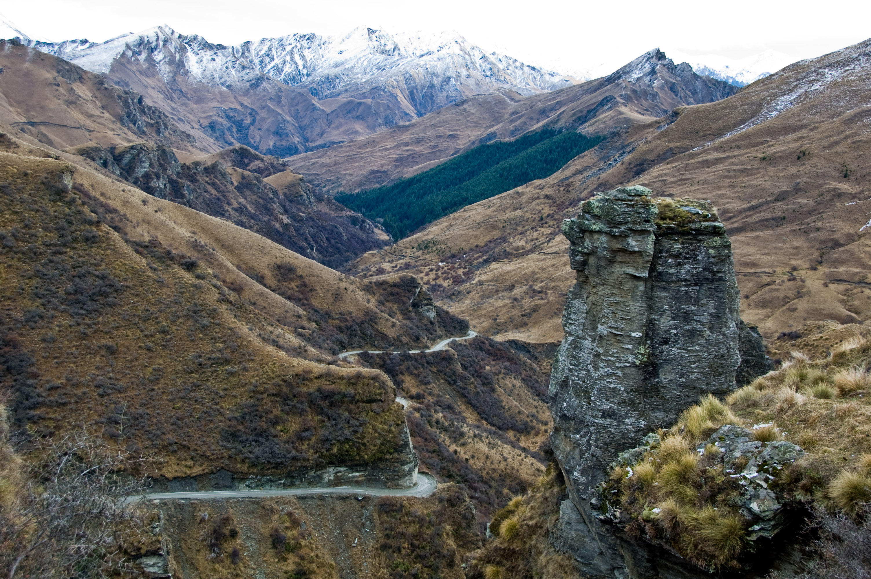
A short way from the airport brought us to a winding road
up one of the lower set mountains that gave some incredible panoramic views of
Queenstown and the surrounding countryside. Besides the magnificent natural
formations, I was also surprised by the remoteness of the area. Immediately
after leaving the airport, nearly all traces of civilization disappeared. The
only things that gave away the fact that humans have ever set foot in this
country were the roads and the spindly fences that made up pens for livestock
across the hills. There were actually a lot of these pens filled with cows,
weird deer creatures which we think were reindeer, and sheep; Oh man were there
sheep. There were sheep everywhere. See that hill? Sheep. Shore by the lake?
More sheep. Huge mountain? Sheep somehow got up there too. They even have
censuses for their sheep. Do you want to know how many sheep there are in New
Zealand? There’s 60 million sheep. Holy sheep. There’s only 3 million humans
living in the entire country. That’s like 20 sheep for every human. Yeah,
there’s a lot of sheep.


So we drove on past the sheep and eventually got to
Wanaka, a quaint resort town at one end of Lake Wanaka. It appeared to be a
classic ski town and we were told that there were some great back country
skiing within a short bus ride… if it had been winter. We unfortunately missed
ski season by a few months, but the town was just as busy as if there had just
been a sick powder day. Every season is tourist season in New Zealand whether
rain, shine, sleet or snow. We explored the town for a while and took a drive
along the lake. Now because New Zealand is so far south and because it is
around the middle of summer in the southern hemisphere, the sun sets very late.
It doesn’t actually start getting dark until around 8 and the sun usually sets
between 9:30PM and 10:00PM on the South Island. It was a weird feeling looking
up at the sky at 9:00 and having it feel like 6:00. I guess it just gives more
time for fun! We had a long drive ahead of us tomorrow so we all hit the hay to
rise with the sun.
 |
| Lake Wanaka |

I did not end up rising with the sun. My bed was far too
cozy and the air was far too cold (40 degrees Fahrenheit) for my poor beach attuned
body. So I conked out again while a couple people braved the elements and
apparently saw a pretty spectacular sunrise. No matter, I caught one later. We
still got up around 7am to begin our drive across the mountains to Fox Glacier
on the western coast. The drive was more of the same, you know? Nothing
special, just more gorgeous mountains, crystal clear lakes, cascading waterfalls,
dense evergreen forests, and endless rolling plains. Just your everyday New
Zealand scenery. But in all seriousness it was one of the most beautiful drives
I’ve ever taken. For me, it is only rivaled by the Great Ocean Road near
Melbourne and the Hana Highway in Hawaii. It sure ain’t no Masspike, amiright!?
We had an all dudes car for the four hour drive so we rocked out to an odd
combination of The Lord of the Rings Soundtrack, Taylor Swift, and 90’s techno.
Our route took us up the sides of the mountains and back down on the other side
toward the coast. On one particularly steep downhill section a strong smell of
burning rubber started filling the car. Pulling over to the side, we joyously
realized that our brakes were getting dangerously burnt out due to the sweeping
downhill roads. But hey, we all die someday, why not go out hurtling off a 500
foot cliff in New Zealand?


We got into Fox Glacier (It’s the name of the town, and
the glacier) after a bit of an almost-running-out-of-gas scare because there
are so few towns along our route, but we made it in one piece nonetheless.
There we met out British tour guide, Duncan, who would take us to the glacier.
They gave us some hiking boots and some snazzy rain jackets so we could look
dapper on our walk. We also relayed our break problems and everyone said that
you had to manually shift to a lower gear to navigate the steep roads and that
burnt out breaks were a common problem there. The advice helped for the rest of
the trip. Duncan led us into the glacial basin where Fox Glacier used to reside
just a few years prior. He was able to give us landmarks on where the glacier
used to extend to and it was astonishing to see how far it had receded in such
a short time. In its wake, Fox Glacier had left an incredible valley that rose
hundreds of feet on both sides. The walls were still extremely unstable and we
had to stay on a set path through the center of the valley to avoid any rocks
that may decide that they want a change of scenery. Duncan showed us some boulders
the size of minivans that had fallen just a few months ago and that was enough
to keep us in step. He was also able to explain how different levels of organic
growth indicated where the glacier used to rest and how long it had been since
it had melted there. We were able to see the entire timeline of this behemoth
mass of ice before we ever laid eyes on the actual glacier. There was a steady
river constantly running out of the glacier that had a milky white tint to it.
This surprised me because I automatically assumed any water from the melting
ice would be crystal clear. As if reading my mind, Duncan explained that as the
glacier moves (Up to 5 meters a day), it grinds the rock below it into a fine
powder that is picked up by the water rushing downhill. The minerals from the
rock flow with the current until it reaches a calm point where the rock
sediments can sink to the bottom of the river. The only thing left behind are
tiny flecks of mica that stay suspended in the water. These particles of
silicate refract light entering the water which gives standing glacial water
its distinct royal blue tint. Yes, glacial water is naturally very clean from
the ice, but the true reason for its vibrant color is just bits of rock. Whouda
thunk?


The squad continued our trek through the glacial basin,
rounded a particularly dangerous slope of unstable rocks and then we saw it,
Fox Glacier, in all of its glacier-y glory. Despite being only a fraction of
its former size, this natural phenomena was still gigantic. It snaked like an
overfed python through the valley before disappearing into the mountains and
clouds. The clouds gave the ice a soft blue glow that contrasted the rock that
marbled the jagged frozen waves. It was quite the sight to behold.
Unfortunately, the current head of the glacier was too treacherous to reach so
we couldn’t get close enough to actually walk on it, so we did the next best
thing: fish big pieces of it out of the river. We snagged a few big chunks of
ice from the fast moving current and we were amazed by how heavy they were. It
was incredibly dense from thousands of tons of ice and rock pressing down on it
for years. We also discovered while “ice fishing,” that the water running out
of the glacier was actually super cold. So we did the most American thing we
could think of and had a competition to see who could keep their hand in the
longest. Duncan dropped out pretty quickly and so did most of the girls, but
the rest of us were in it for the long haul. In the words of the great
Gerard-Leonidas-Butler, “No retreat. No surrender. That is Spartan Law,” and
who the hell were we to disobey Spartan law? So we kept our hands in until we
lost complete circulation and probably caused some irreparable damage, but hey,
Leonidas would be proud.
 |
| Fox Glacier from a distance |
 |
| A little closer |
 |
| Duncan and the Goons |
After warming up a bit, we bid Fox Glacier adieu and started
the journey back to town. We had nearly the entire day free tomorrow so we
asked Duncan if there was anything he recommended in the area. He told us of
Roberts Point track, an apparently beautiful trail with swing bridges that went
along the Franz Josef Glacier. Franz Josef was actually where we were staying
that night so we thought this would be a perfect way to start our day.
Franz Josef was a tiny town, with only about 300
permanent residents. We were able to walk end to end in just a few minutes.
Nevertheless, the locals were nice and we got dinner at a pretty cool bar in
town. We played some pool in the hostel, discussed our plan for tomorrow, and
then drifted off to bed. In order to get the hike in on top of driving back to
Queenstown, we all were going to wake up for sunrise.
It was even colder the next morning. I’m telling you,
three and a half months in steady 80+ degree heat really makes you into a sissy
for a 40 degree wake up call. Luckily I had brought layers and I was excited
for the hike today. We packed everything up and drove the short distance to the
Franz Josef glacier parking lot. The sun had already officially risen from the
horizon, but we had some 9,000 foot peaks in our way to the east so we realized
pretty quickly that we wouldn’t be seeing it for another few hours. So we
started the 5.5 hour hike on the Roberts Point Track.

The walk was spectacular. It was a difficult hike, no way
around it, but the views we got were awesome. The trail led us along the
western side of the glacial valley and a huge mountain crested the east side of
the valley. The early morning sun hit the ridge in the most dramatic way
imaginable. We met 3 separate swing bridges on the hike, the longest being 111
meters and I couldn’t resist playing the Indiana Jones theme music when we
crossed them. It didn’t help the people with a fear of heights. The 11
kilometer track led us past dozens of waterfalls and a few great lookouts over
the valley. The climb got increasingly steeper as the day went on and the
constant waterfalls left the rocks and roots slippery. It was no surprise that
the 10 of us split up into 2 or 3 groups while on the trail.

 |
| Mike Vs. The Temple of Doom |


As the terrain got
harder, we all secretly hoped that Roberts Point Track would have a separate
return trail that would save us from having to climb down the slick slopes from
which we had come. The last section of the trail was very densely wooded and
Lou, Tim, and Shane had gotten a few minutes ahead of me. As I heard their
voices grow louder, I saw a wooden platform appear through the trees. Climbing
up the new looking steps, the sky opened from the canopy and the three goons
from the leading group sat lounging on a picnic table. Lou sat up and said, “we
have good news and bad news.” I knew the bad news already: there wasn’t a
return trail. We would have to double back and do the same thing over again, a
prospect that didn’t bother me so much, but something I knew the latter group
would not be too keen on. So as I stood admiring the view back over the trail
we had come, I asked what the good news was. Lou spoke up again, “turn around.”
In the increasing morning light, burrowed into the tall
walls of the valley, the Franz Josef Glacier sat frozen, stoic, and resolute.
Of all the things I have seen this entire semester, this was the one scene that
legitimately took my breath away. The Fox Glacier was cool, no doubt, but Franz
Josef from this viewpoint, hundreds of feet in the air, was otherworldly. The
platform gave panoramic views of the entire valley: enormous gushing
waterfalls, snowclad peaks, sheer rock faces, and even the shimmering ocean,
only a sliver in the distance. The crown jewel was obviously the glacier, which
glowed icy blue from the growing sun. The 3 hour arduous walk made it all the
sweeter as well. Any tiredness I had from the hike was instantly washed away
and just when I thought that this moment couldn’t get any better… the sun rose.
High behind us, over the towering mountains of the East, the sun had finally
made it high enough in the sky to overcome the colossal New Zealand Alps and
drench the valley with its warming rays. Pictures will never do it justice and
words will never truly describe the way that morning felt. I could have stayed
on that platform for hours.


 |
| The sea in the distance |
 |
| sunrise |

About
20 minutes after I “summited” the rest of the group joined us atop the platform
and we all sat to admire the sights and ate some sandwiches. Shane, Lou, and
Tim were the fastest bunch and they decided to set off before the rest of us to
gain some much needed shut eye in the car. The ladies left a while after them
and Liam, Matt, and I stayed longer at the top drinking in the views. We caught
up to Julia and Court and helped guide them through the rugged terrain that we
had climbed up. Although it was quicker going down, it was significantly more
slippery. Everyone did great though and we scuttled over the rocks, past the
waterfalls, through the streams, and across the bridges in a fraction of the
time it took to go the other way. We reached the cars out of breath and sweaty
but all in good spirits.
Having
already checked out of our hostel, we again loaded back into the cars for the ride
back into Queenstown. We took the same road (likely the only road) back through
the mountains and into the heart of Queenstown. I could continue writing about
all of the beautiful sights along the way but I think you get the idea at this
point. For those other Lord of the Rings fans out there though, we later found
out that the mountains around Franz Josef were used in the scenes of Return of
the King in which Pippin, per Gandalf’s instructions, lights the warning
beacons of Gondor to signal for Rohan’s aid for the upcoming battle of Minas
Tirith. If you’ve never seen the Lord of the Rings, you probably didn’t understand
a word of that sentence… and you should probably see them or else we can’t be
friends.
Queenstown was a lot smaller than I was
expecting for being one of the largest cities on the South Island. It had the
same ski town feel as Wanaka but with a lot more amenities. Also like Wanaka,
it sat at the end of a huge glacial lake. Upon arrival in Queenstown, we
learned that a big group of our friends from Bond were also in town that
night. They were doing a more structured trip around New Zealand that week but
we didn’t think any of our dates overlapped. It was a pleasant surprise. They
told us they had signed up for a pub crawl and so a few of us tacked onto their
group, got some free drinks at a couple bars and had a fun American night out.
The
next morning was reserved for white water rafting the Shotover River. Rafting
is one of the few adventurous activities I had yet to do so I was pumped. In
order to get to the spot where we would launch, they loaded our wetsuit clad
bums into a van and informed us that we would be driving on the most dangerous
road in New Zealand and the 13th most dangerous road in the world.
Considering that there are over 69 million roads in the world, #13 for
deadliness is a pretty respectable feat. And in a rickety tour bus twice the
size of a normal car pulling a trailer of 6 rafts, let’s goooooooooooooo.
They
sure weren’t kidding. The Skipper’s Canyon Road was a former dirt track used by
gold prospectors in the 1800’s. The road was absurdly narrow and hugged the
steep edge of a valley that led to a couple hundred foot drop a few inches to
the right. It was one of those things you see the first time, laugh out loud,
and think “you can’t be serious.” It was insane. At one particular bend in the road, in order to
get around the corner, we had to drive with one tire off the edge of a cliff in
a spot where the entire weight of the bus was resting on an old handmade brick
wall that used mud and horse crap to hold together. Lovely. One of the raft guides rode
with us and gave some Queenstown history to everyone who wasn’t praying for
dear life. He told us that Queenstown was born out of a huge gold rush in the
1860s. At one point, the Shotover River, where we would be rafting, was the
second most gold rich river in the world. Shacks and old mining equipment still
scattered the river and the valleys where miners worked and lived. The views
were spectacular too, if you could overcome the fear of imminent death.
 |
| Courtesy of google, because we didn't have our phones on us |
 |
| From google too |
We
eventually made it to the bottom of the road and the place where we would be
rafting from. Because some people freak out right before doing extreme things,
like rafting, it is not unusual for some to back out of the activity at the
last minute. On this particular rafting trip though, backing out meant a ride
back up the Skipper’s Canyon Road
which, hilariously, is more likely to kill you than just going rafting. So
naturally, no one went back on that bus.
The
rapids that day were mostly class 3 with some class 4 sections so they were
nothing to scoff at, but with adrenaline still pumping from the bus ride, we
were ready to go. Courtney, Liam, and I were grouped up with two older couples
from Sydney and our American tour guide, Sean. I swear, we must have met every
American on this continent at this point. Sean was an entertaining dude from
Missouri who just travels around the world and works as a rafting guide. The hour
and a half rafting trip began with some calm waters and small rapids to
practice the rowing commands. On the way to the bigger stuff, we passed tons of
old mining equipment that was left to rust after the gold in the Shotover River
ran dry. Huge dredgers, cranes, and complex pulley systems lined the towering
walls of the valley. We got to jump into the river a few times and even with
the wetsuits on, the water was frigid. The class 4 rapids were pretty intense,
we got jostled quite a bit, but amazingly, no one fell out. The last leg of the
trip took us through an old mining tunnel bored into the side of a mountain.
The tunnel was pitch black and the current ripped us through, making it feel
like more of a Disney World ride than a raft. When we broke through to the
other side, a 10 foot waterfall awaited us and after plunging over that, we
floated safely back to the raft shop. It was a lot of fun. We hit up the sauna
in the rafting place to warm our chilly toes then headed back into Queenstown
for our next adventure.
 |
| Bridge over the Shotover |
Like
the rafting, we had booked a gondola ride and a mountain luge when we first
planned our trip. The gondola went from the edge of Queenstown and up the side
of a steep mountain that gave spectacular views of the city and its surroundings.
Along with the luge, a bungie jump and 5 star restaurant sat atop the mountain.
After another short chairlift, we were brought to the luge, which featured
controllable carts on a concrete track spiraling down the mountain. You could
really pick up some speed and we enjoyed racing each other for about an hour or
so. We took the gondola back down where we split up into the nerds and the
non-nerds. The nerds, including yours truly, Matt, Tim, and Liam went on a
quest to find some more Lord of the Rings sites.
 |
| Queenstown, as seen from the luge |
Scenes
from the trilogy were spread out over the entire island and many tour companies
try to keep the actual locations on the down low so they can still make money
off their tours. Without a tour or a map telling us exactly where the
locations were, we had to settle with sifting through google. While doing my
research in the car, I realized that the Shotover River, where we had rafted,
was the location for the Gates of Argonath in the Fellowship of the Ring.
Argonath is the place where two massive statues flanked the river where Frodo
and the gang were sailing down. The statues were computer generated so we don’t
know exactly where the shot was taken but nonetheless, we too went down that
river!
Also
in my research, I found another location close to Queenstown in Arrowtown. It
was only 20 minutes away so I pointed us in that direction and we got driving.
Arrowtown was a tiny place that looks like it’s still in the midst of the gold
rush. Classic old west style buildings comprised Main Street and it had a
nicely settled aura about it. We followed some GPS coordinates I had found
online and made our way to the Arrow River that hugged the side of Arrowtown.
After some bushwhacking and stream jumping we got to the same shores that Arwen
saved Frodo from the Nazgul by conjuring a giant wave. This scene, also from
the Fellowship, represented the Ford of Bruinen and though it only lasted a few
seconds, it was cool to be at the same (or at least close by) place where they
had filmed it. Again, if you’re not Lord of the Rings fanatics like us, it just
looks like another river.
 |
| Ford of Bruinen |
Satisfied
with our small brush with Middle Earth, we went back to Queensland, got some
dinner, watched the sunset, then explored the town some more. Tim, Liam, and I
split off that night and went to a cool bar called Winnie’s. There was live
music from a guy using looping pedals and a violin, guitar, and bass guitar to
make some really funky remixes to famous songs. We met a few really fun local
kiwis and hung out with them for the night.

Wednesday
was dedicated mostly to Milford Sound; a huge fjord, inlet, mountain, bay,
valley hybrid thing. It was another 5ish hour drive for us from Queenstown that
took us through, unsurprisingly, even more beautiful countryside. After a brief
hiccup of missing our first ferry out to the sound (by literally one minute I
may add), we boarded up the boat for a couple hour spin around the sound. The
geographical makeup of the area is mind-blowing. Milford Sound was created when
the Tasman Sea flooded an enormous glacial valley millions of years ago. With a length of over 12
miles and average width of 2 miles, it snakes through the uninhabited expanses
of the east coast. Seeing as it was originally formed by a glacier, towering
mountains rise directly from the water reaching peaks of over 5,000 feet (The
largest mountain being 6,710 feet). Plunging steeply beneath the water, the
sides of the valley extend down to 1,600 feet below sea level. The cruise led
us straight through the fjord and past the sites which have led some to hail
the sound as the 8th natural wonder of the world. From the windy
decks of the boat, it was hard to disagree. Cascading waterfalls tumbled
thousands of feet down the mountainsides while sea lions lounged in the sun. The
fjordland crested penguin enjoys the cold waters of the sound and is one of the
rarest species of penguins in the world. We were lucky enough to capture the
sight of a pair of fjordland crested penguins waddling around the rocks, doing the
usual adorably awkward penguin things. After reaching the Tasman Sea at the far
end of the sound, we made our way back on the opposite side of the valley. Near
the end of the voyage, the captain came on the loudspeaker and announced that
we would be going underneath one of the thundering waterfalls and whoever didn’t
want to get wet should come inside. Us, being the boneheaded Americans we are,
decided to be the only ones to remain on the bow of the ship. (remember that
whole Spartan law thing?) Well, we got drenched. With ice cold, melted-snow
water. In the windiest part of New Zealand. And we are the future leaders of America
ladies and gentlemen. It was actually really refreshing and we had changes of
clothes in the car so we were fine. The captain did
complement us on our bravery via loudspeaker and informed us that we had
received a glacial facial. Ha.


 |
| Sea Lions |
 |
| The penguins, a little hard to see but right in the center |
 |
| The waterfall |
 |
| Underneath the waterfall |
We
stopped in a place called Te Anau on the way back from Milford Sound for some
more Lord of the Rings stuff. The same website that gave the coordinates to the
Ford of Bruinen was also able to guide us to the River Anduin, which was the
river the fellowship sailed down before getting split up at Amon Hen. A hop
skip and a jump away was the Dead Marshes, or the spot where Smeagol led Frodo
and Sam on their quest to reach Mordor. The dry season left the Dead Marshes
more dry than marshy, but we could definitely see the appeal of the filming
location. The reason why these sites were so cool to us is that they gave a
real world location for a place that would normally only exist in the
imagination. Tolkien is famous for his descriptive writing for his locations of
Middle Earth, so to see them brought to life is pretty awesome. It also gives
me grounds to yell at the screen “I’ve been there!” whenever I watch the Lord
of the Rings in the future.
 |
| River Anduin |
 |
| The Dead Marshes |
We
were almost back to Queenstown when we saw a line of cars stopped in the middle
of the road. As we drew closer, a noise arose from ahead on the road. It grew
louder and louder until it seemingly engulfed us. It was the reason for the
stopped cars. It was the reason for the confused looks. It was the reason for
fuzzy socks. It was the sound… of baaing. Remember those sheep, all 60 million
of them? A flock of a couple hundred was being relocated from one pen to
another by a couple of ranchers and their border collies, and this meant that
the road had been taken over by the fluffy creatures. From curb to curb, the
sheep sat lazily, bleating their hearts out, and occasionally walking a few
steps before stopping and looking around, clueless once again. It was a sight
to behold. We were in no rush so we all sat outside the car windows as we
inched through the throngs of wooly animals. Between the little lambs chasing
after their mothers and the waddling chubby ones who looked like a cotton ball
had sprouted tiny limbs, we couldn’t help but laugh at the spectacle. It took
us almost 30 minutes to move through the flock and we enjoyed every second. Only
in New Zealand.


We
got back into Queensland and ate dinner at a bar that sold $1 pizzas in the
first 10 minutes of each hour. With cheap drinks and cheaper food, it was a
godsend to our college wallets. After leaving the bar, we found our two Swedish
roommates, Charlotte and Dani, and hung out with them around town. It was a great
way to spend our last night in New Zealand.
When
we awoke the next day, we had to bid farewell to the country that had spurned
so many adventures. We decided to add one more to the list as we drove around
the lake where New Zealand was situated, looking for a cliff jump that Duncan
had told us about. We never found the exact spot of the 50 foot cliff, but we
did find a nice rocky shore that allowed for one last swim. It was a quick
polar bear plunge in the 45 degree water, but it was a fitting way to end our
trip. Spontaneous and a little bit crazy. Just like the Goon Squad.


It is hard
to express the splendor of New Zealand in words. If there is one place on this
planet I would recommend someone to go, it would be there. For as long as I can remember, New Zealand was my travel holy grail, and it certainly did not disappoint. It is fitting to end the semester with a trip of such magnitude, and to share it with a group of people who became some of my best friends in four short months is something that can't be overstated. New Zealand was hands down my favorite trip of the semester. With breathtaking sights, a phenomenal group of friends, and 60 million sheep, what else could a guy ask for?
No comments:
Post a Comment